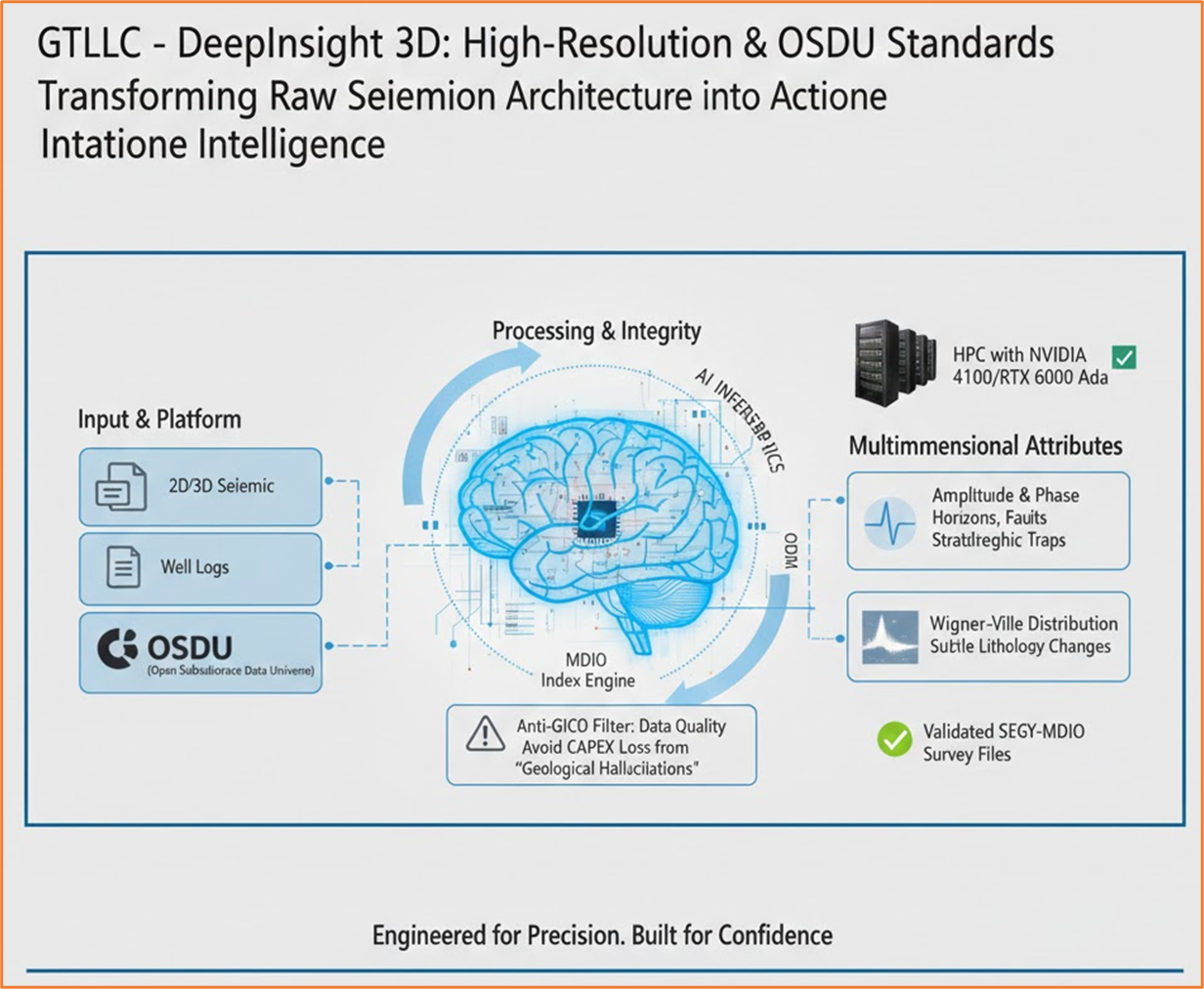
The New Era of Seismic Interpretation
Transform thousands of 2D seismic lines into reliable subsurface models using AI, data engineering, and ETL pipelines designed to eliminate multi-million-dollar interpretation errors.
Why Are We Still Drilling Dry Wells in 2026?
The oil & gas industry faces a silent but devastating challenge. Decades of 2D and 3D seismic data sit in heterogeneous formats across disconnected systems. Meanwhile, the seasoned geoscientists who could interpret this data with field-tested intuition are retiring.
The incoming generation of interpreters has been trained primarily on screens—with limited exposure to the operational reality of the subsurface. The result? Wells that find water where oil was expected, costing millions of dollars per misinterpretation.
According to industry estimates, up to 70% of seismic data collected worldwide has never been fully reprocessed with modern algorithms. This massive archive of untapped subsurface intelligence sits in legacy formats—SEG-Y files on tapes, proprietary databases, and disconnected spreadsheets—waiting for a systematic approach to unlock its value.
Every dry well costs between $5M and $20M in exploration-stage expenditure. Multiply that by the hundreds of misguided drilling decisions made each year, and the industry hemorrhages billions that could be saved with better data integration and AI-assisted interpretation.
“If you already have all the data, why are you still drilling blind?”
What Is a 2D Seismic Line?
A cross-sectional image of the subsurface generated by geophones and acoustic waves. Each trace is a column of information that, when combined, forms a stratified picture of rock layers beneath the surface.
Why Is Interpretation So Hard?
Seismic data does not show oil directly—it reveals acoustic contrasts. Distinguishing water, gas, or light crude requires deep experience, geological context, and complementary well data that is often siloed or unavailable.
GIGO: When the Problem Isn't AI—It's the Data
GIGO (Garbage In, Garbage Out) is the iron law of data science: no model, no matter how sophisticated, can compensate for data that is poorly formatted, mislabeled, inconsistently correlated, or incorrectly interpreted.
In Seismic, GIGO Happens When:
- SEG-Y headers are corrupt, incomplete, or inconsistent.
- Coordinate reference systems are not unified or documented.
- There is no explicit relationship between seismic data, well logs, and velocity models.
- Historical interpretations are unstructured and unversioned—making them impossible to audit or reproduce.
How to Prevent GIGO
The answer is not “more AI”—it's better data engineering:
Financial Impact of GIGO
Applying AI on uncurated seismic data generates “geological hallucinations”—false positives that lead to drilling non-existent targets. This translates to a total loss of CAPEX investment. Our pipeline shields your capital by ensuring only high-purity data enters the inference engine, mitigating the risk of decisions based on algorithmic noise.
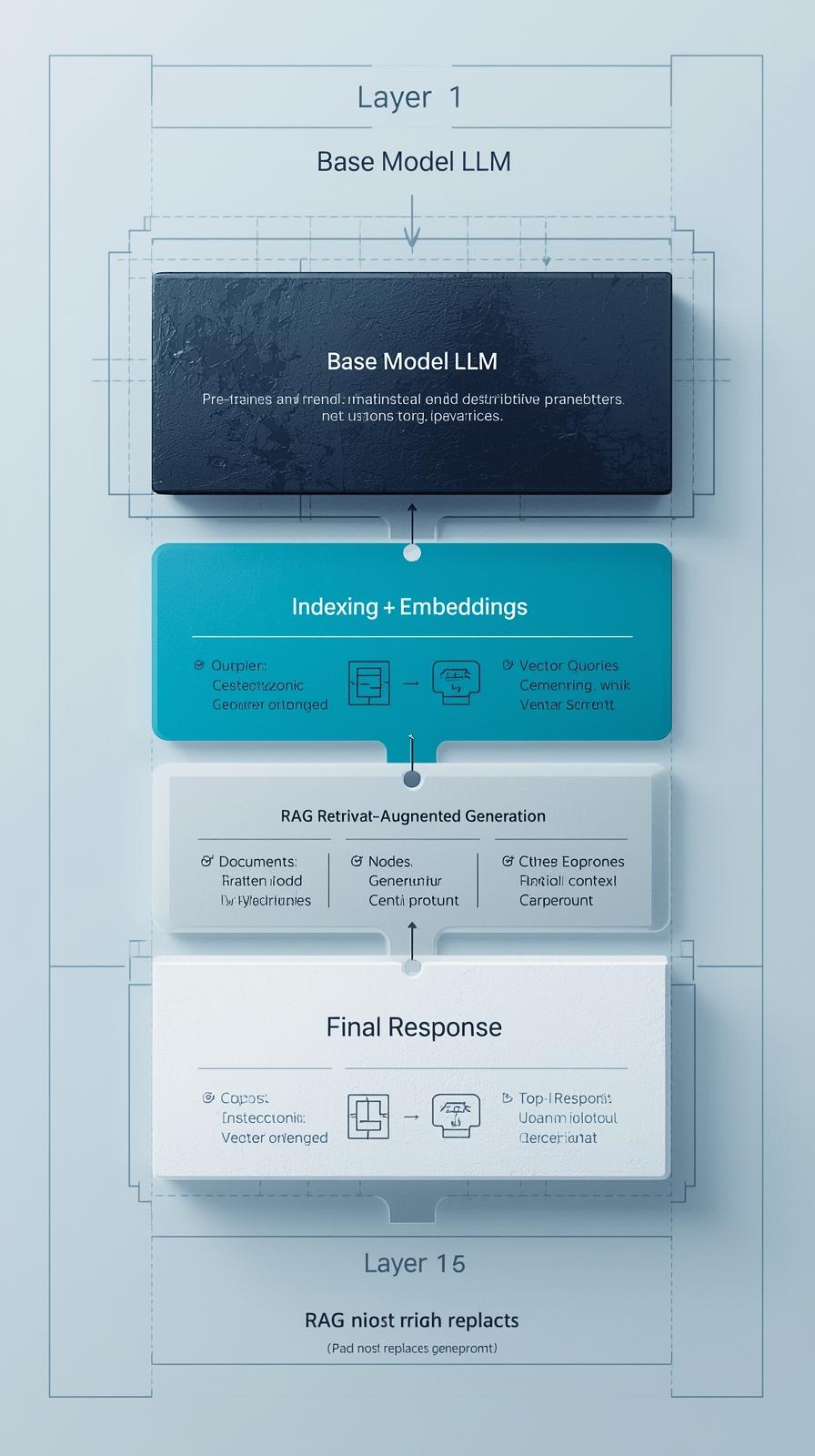
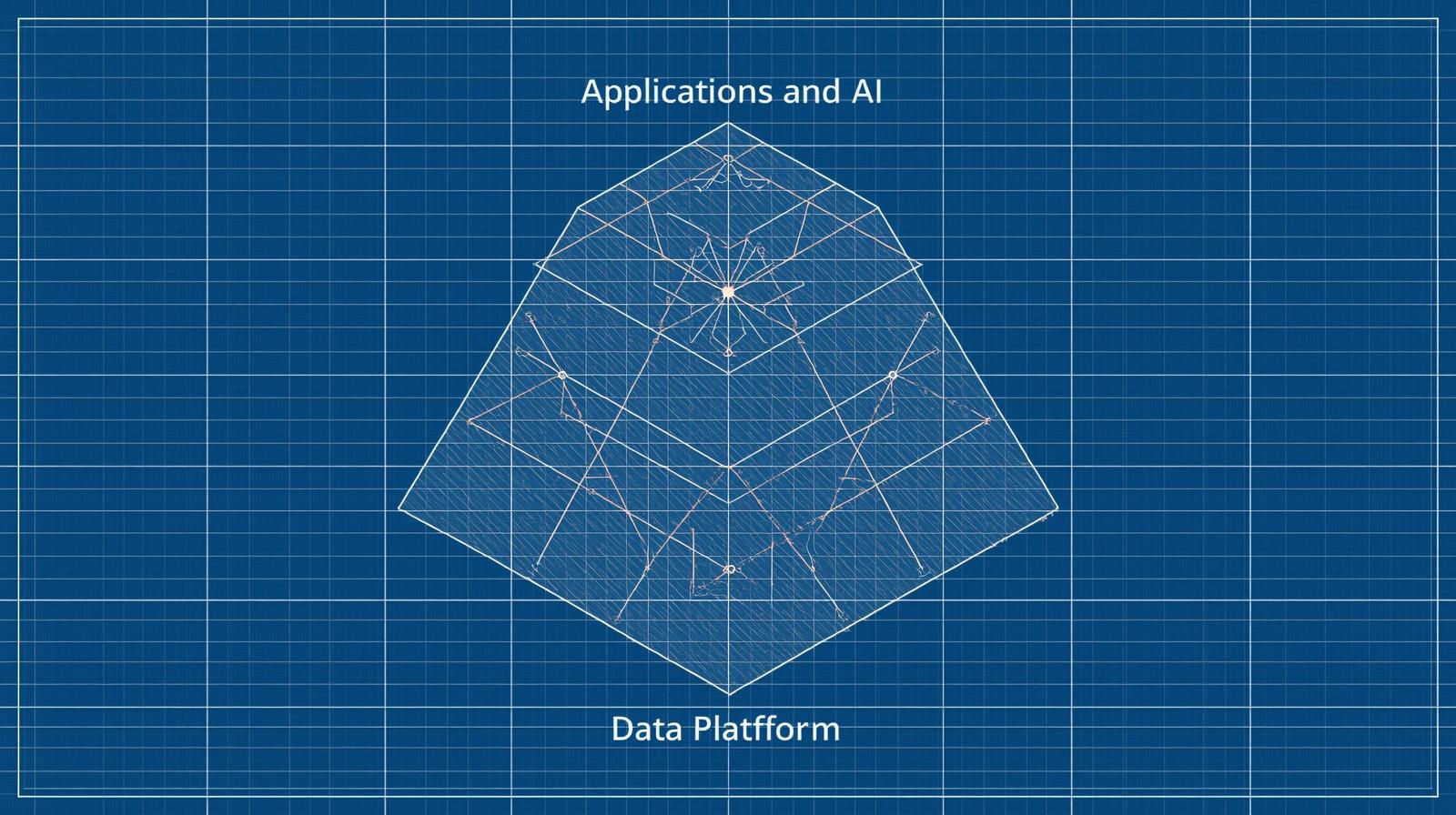
OSDU: The Single Source of Truth for Energy Data
The OSDU® Forum (Open Subsurface Data Universe) is an international technology consortium under The Open Group. Its mission is to transform the energy industry by creating an open, vendor-neutral, cloud-native data platform standard.
Historically, the energy sector has operated with data silos— information trapped in proprietary formats and closed systems. OSDU breaks these silos by providing a common language for all subsurface data: seismic, geological, well, production, and more.
Why OSDU Matters for Your Project
- Standardizes seismic data and metadata across all formats and vendors.
- Integrates seismic with wells, tops, velocity models, and interpretations in one place.
- Enables AI-optimized formats like MDIO (Multi-Dimensional Input/Output) for parallel, streaming access to traces.
- Guarantees traceability, versioning, and data lineage for every volume and attribute.
- Eliminates vendor lock-in—runs on AWS, Azure, GCP, or on-premise.
How OSDU Works in Practice
OSDU provides a set of RESTful APIs and standardized schemas that allow any application—whether proprietary or open-source—to read and write subsurface data in a consistent way. Instead of each software vendor defining its own data model, OSDU defines a universal blueprint.
When a geophysicist loads a SEG-Y volume, OSDU automatically catalogs its metadata: survey geometry, coordinate reference system, acquisition parameters, and processing history. This means that any team member, anywhere in the world, can discover and access that volume through a simple search—no more emailing files or hunting through shared drives.
For AI workflows specifically, OSDU's data governance layer ensures that every training dataset is versioned, traceable, and reproducible—a critical requirement for regulatory compliance and scientific rigor in exploration decisions.

Who Is Behind OSDU?
Operators
ExxonMobil, Chevron, Shell, Equinor, TotalEnergies, BP
Cloud Providers
Microsoft Azure, AWS, Google Cloud, IBM
Service Companies
SLB, Halliburton, Baker Hughes
Open Source
Community-driven GitLab repositories, APIs & schemas
What Is MDIO?
Multi-Dimensional Input/Output is an open format optimized for AI/ML workflows. It enables lossless compression, random access to traces, massive parallel streaming, and direct integration with ML training pipelines on any cloud platform.
MDIO allows your AI models to consume seismic volumes without duplicating data—streaming traces directly from the data lake to the GPU.
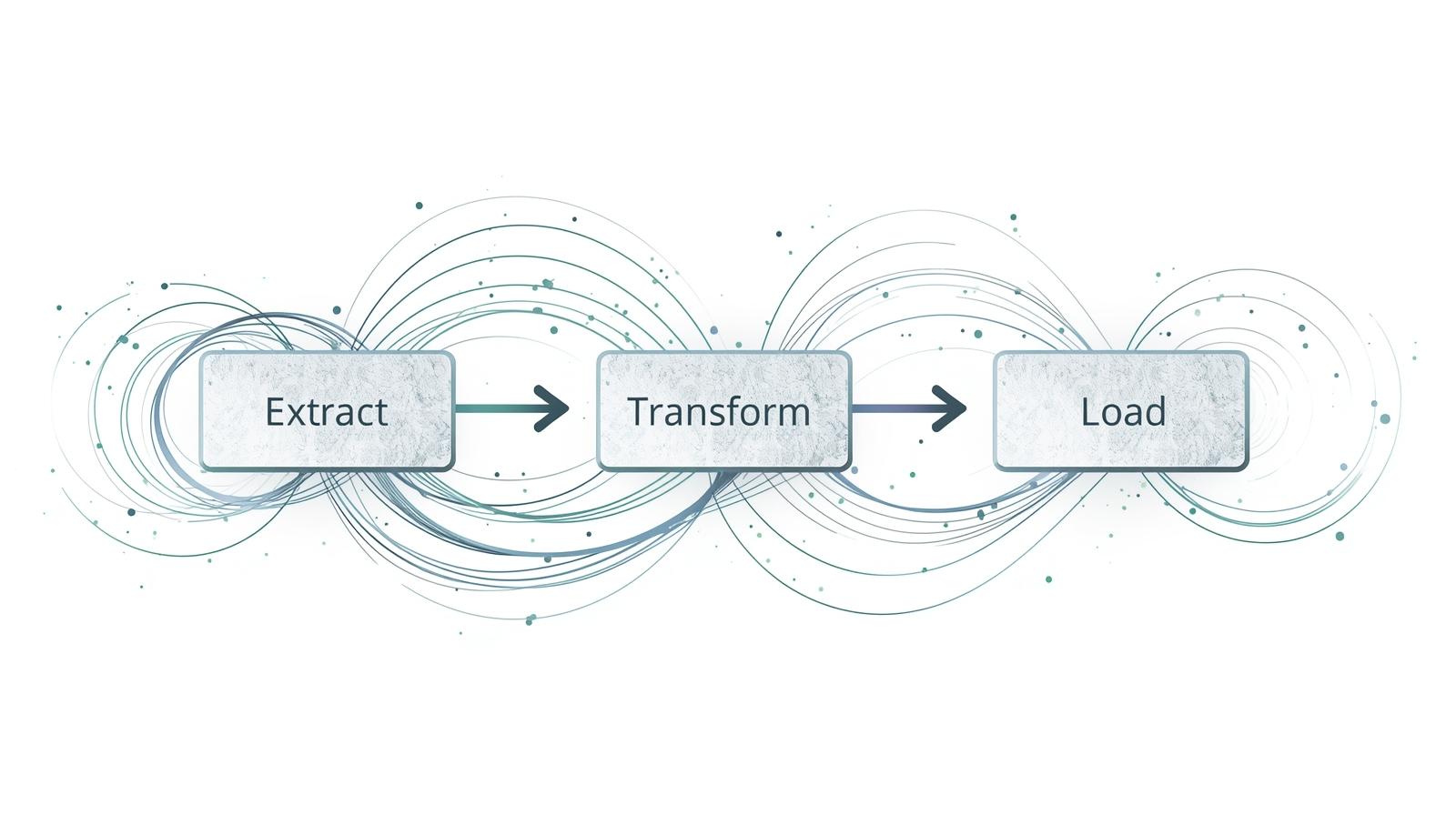
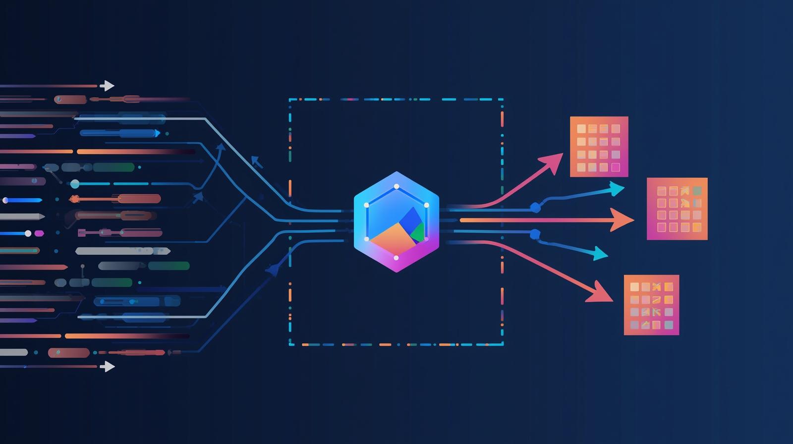
ETL for Seismic Data: From Raw Files to AI-Ready Datasets
A well-designed ETL (Extract, Transform, Load) pipeline is the backbone that converts raw seismic data into trustworthy, trainable datasets. Without it, every interpretation is an isolated experiment. With it, every step is documented, reproducible, and auditable.
Extract — Ingest from Heterogeneous Sources
Ingest seismic 2D/3D files (SEG-Y, SEG-D), well logs (LAS), structural tops, velocity models, and prior interpretations. Register metadata and validate file integrity using OSDU's Data Ingestion Workflow with schema osdu:wks:work-product-component--SeismicTrace:1.0.0.
- • Validate inline/crossline consistency, sample rate, geometry
- • Detect dead traces, amplitude clipping, corrupt headers
- • Register acquisition parameters and coordinate reference systems
Transform — Clean, Enrich & Prepare
This is where raw data becomes intelligence. Transformations include:
Data Cleaning
- • Header & CRS correction
- • Amplitude normalization
- • Band-pass filtering & deconvolution
- • Dead trace elimination
AI Preparation
- • Seismic attribute computation (coherence, semblance, AVO)
- • Well-tie correlation
- • 2D/2.5D/3D patch generation
- • Label generation from drilling results
Load — Store, Version & Expose for AI
Load transformed data into OSDU as the single source of truth. Export AI-ready datasets in optimized formats:
Every volume, attribute, and label carries full lineage and versioning—ensuring audit-grade reproducibility.
How to Train an AI That Identifies Oil with >90% Accuracy
AI does not replace the geologist—it amplifies their capabilities and preserves their expertise in a system that learns continuously with every well drilled.
What Does the AI Learn?
- Acoustic patterns associated with different lithologies
- Seismic signatures of water-oil contacts
- Derived attributes invisible to the human eye
- Correlations between seismic data and real drilling outcomes
What Does the AI Need?
- Clean, curated data (no GIGO)
- Reliable labels from drilled wells & senior geologists
- Balanced seismic patches (positive & negative cases)
- Cross-validation by field/area, not just by trace
Deep Learning Architectures for Seismic AI
U-Net 2D
Horizon detection & structural segmentation in 2D seismic sections
U-Net 2.5D
Lithology classification using stacks of 5–15 traces for facies analysis
3D U-Net
Volumetric analysis on patches (64³ voxels) for full 3D subsurface modeling
CNN + Attention
Prospect classification with global context via transformer mechanisms
How We Measure Success
Accuracy alone is not enough. We use industry-standard metrics designed specifically for seismic classification:
ROC-AUC
Overall ability to distinguish oil from water across all thresholds
Precision-Recall
Balance between finding all prospects and avoiding false alarms
IoU / Dice
Overlap accuracy for fault and horizon segmentation maps
False Positive Rate
Directly measures the risk of drilling dry wells
Hausdorff Distance
Edge robustness for fault boundary detection
Cross-field Validation
Ensures models generalize across different geological areas
Why 90%+ Accuracy Is Realistic
AI can learn from thousands of examples where a human interpreter sees only a few. The key is not a “magic model”—it's a solid, traceable data pipeline combined with disciplined training, rigorous validation by field/area, and a continuous improvement cycle where every new well drilled feeds back into the system.
From Raw Seismic Data to the Optimal Drilling Decision
This is the complete pipeline a CEO needs to understand: a step-by-step path that converts chaotic legacy data into science-backed drilling recommendations.
Ingest & Register
Upload SEG-Y files → register metadata in OSDU → validate quality (dead traces, geometry, CRS).
Convert to AI Format
Transform seismic to MDIO for efficient parallel access and streaming without data duplication.
Enrich with External Data
Integrate well logs (GR, RHOB, DT), structural tops, velocity models, and public data (NASA, USGS, TGS DataVerse).
ETL Transformation
Normalize amplitudes, compute seismic attributes, generate 2D/2.5D/3D patches, label with real drilling results.
Train AI Models
Train U-Net, CNN+Attention, and 3D models on curated datasets. Validate by field/area. Target ≥90% precision.
Deploy & Run Inference
Deploy models that consume MDIO via streaming. Generate probability maps and risk indicators in real time.
Visualize & Decide
Present results in OSDU-compatible applications. Deliver drilling coordinates (X,Y), target depth, and risk profiles.
Feedback & Improve
Every new well drilled feeds back into the system. Human interpretations are registered in OSDU to continuously improve model accuracy.
Technical Manifesto — Single Source of Truth
project:
  name: "AI-Powered Seismic Interpretation"
  goal: "Reduce dry wells via a reproducible data + AI pipeline"

principles:
  - GIGO: "Without clean data, there are no reliable decisions"
  - single_source_of_truth: "One centralized platform for seismic, wells & models"
  - traceability: "Every datum has lineage and version"

etl:
  extract: [seismic_2d_3d, wells_and_logs, velocity_models, prior_interpretations]
  transform:
    - header_correction    - amplitude_normalization
    - seismic_filtering    - attribute_computation
    - well_tie_correlation - patch_generation_2d_2.5d_3d
  load:
    destination: "OSDU Data Lake"
    formats: [MDIO, Zarr, Parquet]
    versioned: true

ai_model:
  architectures: [unet_2d, unet_2.5d, unet_3d, cnn_attention]
  objective: "Probability of hydrocarbon presence per stratum"
  target_accuracy: ">= 0.90"
  metrics: [roc_auc, precision_recall, false_positive_rate]

continuous_improvement:
  - pilot_deployment
  - validation_against_real_wells
  - geological_feedback_loop
  - model_retraining
- scaled_deploymentStrategic Benefits for Your Organization
Capital Efficiency (CAPEX)
Drastically reduce operational costs by avoiding slow and expensive physical 3D surveys. Optimize budget for the production phase.
Drilling Risk Mitigation
Predictive visualization of targets with >95% certainty before mobilizing equipment—eliminating trial and error in the field.
Time-to-Oil Acceleration
Reduce the exploration cycle by up to 80%. Transform 2D lines into decision-ready models in a fraction of conventional timelines.
Full OSDU Interoperability
Native integration with international operators' workflows, ensuring your digital asset is compatible with any industry platform.
Target Inventory Optimization
Generate a complete inventory of drilling targets across the entire acreage block for long-term strategic planning.
Predictive Science Precision
Validate targets through joint NASA-Seismo-Electromagnetic inversion, elevating exploration to the standard of modern predictive science.
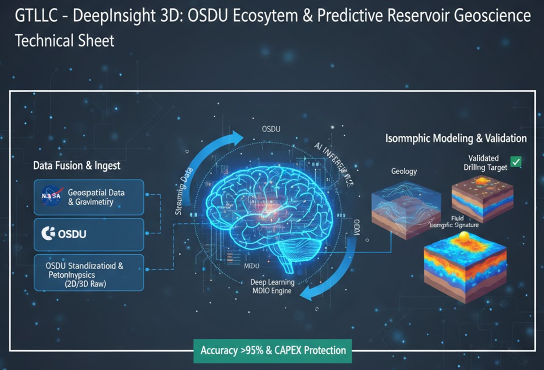
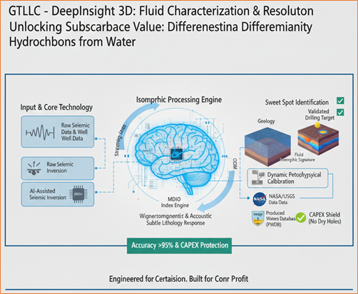
Fluid Characterization: Resolving the Water vs. Hydrocarbon Ambiguity
While conventional 3D seismic is limited to mapping structural geometry, our platform decodes the Isomorphic Fluid Signature. This resolves the historical blind spot of exploration: the difficulty in differentiating low-salinity aquifers from medium/heavy crude zones.
Isomorphic Material Identification
Through AI-Assisted Seismic Inversion algorithms, the system jointly processes density and elastic velocity variations. This identifies the electromagnetic and acoustic response of hydrocarbons versus aquifers—defining the Sweet Spot (optimal drilling target) based on real fluid saturation.
Dynamic Petrophysical Calibration
- Resistivity Adjustment: Calibrate formation resistivity values using regionally detected salinity data.
- CAPEX Shielding: Avoid the confusion between freshwater zones and oil reservoirs, reducing risk of non-commercial wells.
- Contact Validation: Precisely define oil-water contacts (OWC) through isomorphic signature analysis.
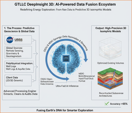
About Global Telecom LLC
Based in Houston, Texas, founded in 2005 and internationally recognized, Global Telecom LLC has over 20 years of leadership in developing technologies for robotics, automation, and AI applications.
Our mission is to transform the energy industry through high-precision, cost-effective solutions. Our DeepInsight 3D platform redefines energy exploration through a Data Fusion Ecosystem powered by Artificial Intelligence.

The Deliverable: A Complete 3D Seismic Analysis Report
Understanding what you'll receive is key to making an informed decision. Here's the structure of a standard 3D seismic interpretation report—powered by our AI pipeline.
Executive Summary
Concise overview of findings, risk profiles, and hydrocarbon volume estimates designed for non-technical stakeholders.
Methodology & Workflow
Detailed technical workflow: seismic processing, well calibration, horizon/fault interpretation, attribute analysis, and AI inference.
Results & Visualizations
Seismic sections, horizon maps, fault models, 3D renderings, and attribute maps (amplitude, coherence, curvature).
Drilling Recommendations
Specific well locations (X,Y coordinates), target depths, structural closure maps, and P10/P50/P90 reserve estimates.
Your Company Deserves Decisions Based on Science, Not Guesswork
Oil exploration no longer depends solely on the intuition of a handful of retiring experts. It depends on your ability to transform seismic data into actionable knowledge through data engineering and artificial intelligence. The next step is yours.
What a CEO Should Do Now:
Recognize the problem: it's not a lack of data—it's a lack of a system to turn data into reliable decisions.
Adopt a unified data platform (OSDU): centralize seismic, wells, models, and drilling results. Eliminate silos.
Implement a seismic-centric ETL pipeline: standardize, clean, and enrich your data. Document every step.
Train AI models on curated data: start with pilots in specific areas. Measure dry-well reduction.
Build a 'digital brain' that learns with every well: experience no longer retires—it accumulates in the model.
Request a Technical Assessment
Send us your seismic data for a preliminary evaluation. We'll show you what AI can reveal.
Contact UsGlobal Telecom LLC
1202 E 1st, #251 — Humble, TX 77338, USA
+1 832-674-6773
+1 832-995-8326
global_telecominc@yahoo.com
daniel@globaltelecom.site
Houston, Texas • Founded 2005 • 20+ Years of Innovation in AI, Robotics & Automation